Bringing Agriculture Together on the map.
Farmapper is a cloud based mapping application and much more. Built from the ground up for farmers, ranchers, landlords and anyone who works in the agricultural industry.
Try it out Learn more


 FARMAPPER
Farm data exchange made easy
If you are a farmer, rancher, landlord or work in the industry then you have a need for a descriptive farm map, which you can easily share with anybody. What about having a farm definition, which can be shown directly on Google Maps or Google Earth?
See video
FEATURES
can do for you?


Easily create
your farm map
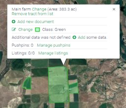
Draw it, build it from preloaded legal description shapes, range allotments, import the polygon shape, customize it with stickers, colors and add data directly to the shape or sticker.

Increase your
bottom line

Leverage your farm project to create and share listings using your map project with hay and forage for sale, equipment, farm for rent, or many more categories. Surf the Channels to find interesting items for sale and listings that are local and on the map.
What do you want
to share
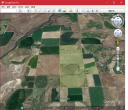
Add deeds, legal descriptions, data, photos, pretty much any file to your farm file cabinet in the sky. Then your farm map can be shared and shown directly using Google Maps or exported to Google Earth.


COMMUNITY
How will you collaborate with Farmapper?
Having a nice farm map is great, but sometimes you want to find somebody to share it with. Farmapper is a community and the ability to customize and share is built into its pedigree. Easily collaborate and share your project with others. Allow them full edit privileges or restrict them to read only.
Learn more